|
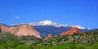
Driving Directions - there's an app for that...Driving Directions to Cripple Creek, Colorado. Well, maybe not step by step directions. Use the Google map or GPS for detailed, specific instructions. These driving directions feature highlights along the way. Don't forget your camera. From I-25: The Front Range of ColoradoI-25 runs along the front range of the Colorado Rocky Mountains. From Colorado Springs, Denver, Pueblo, take Interstate 25 to the Highway 24 exit. Travel west toward Divide, Colorado. Note the view of Pikes Peak from Colorado Springs...you will soon be on the other side.
Go west toward Manitou Springs, a place with...let's say unique atmospheric callings. Manitou is charming with shopping, the cog-railroad, penny arcade, and more. 
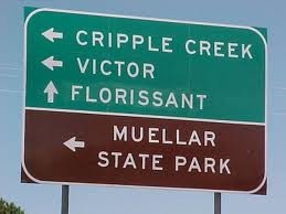
Continue up Ute Pass. Halfway, there's a pull-off with parking for a hiking trail that takes you into Pike National Forest. Next little town is Cascade - there's a cool winery and it's home to Santa and the North Pole (a fun amusement park). Keep going past Chipita Park and Green Mountain Falls. At Woodland Park, you're at about 7,000 feet above sea level and the view of Pikes Peak is incredible. You'll be tempted to stop and check out the downtown area but keep going - 6 miles until the turn. You're doing great! At Divide, turn west on State Highway 67 -there's a light with signage- and go 18 miles - all the way to the other side of Pikes Peak. The entrance to Mueller State park is a short distance from Divide and clearly marked.
Warning Keep in mind there are no services on this pass and limited cell phone coverage. There is, however, plenty to BUZZ about.
The Back WayDriving directions for Teller County Road 1 from Florissant takes you on the back road into Cripple Creek. A scenic drive that goes by the Florissant Fossil Beds National Monument and llama farms. There's a gas station open during the day where Teller County Road 12 from Guffy and Canon City meets Teller County Road 1.
|
 Highway 67 toward Cripple Creek is an amazing mountain road with many places to pull over if you want to take it easy and not hold up traffic.
Colorado Map
Need Directions?
Click the map below to open an interactive Google version or,

click here and zoom in, zoom out, get exact directions, or just explore.
Check the Route
Webcams show weather, driving, and traffic conditions.
Click here - Ute Pass Cams
for views of Pikes Peak and Highway 24 through Woodland Park, Colorado.